Everest Base Camp part I.
Everest Base Camp Trek - GOING UP. Going to see the highest mountain on this planet with Viktor and Hanka- legendary Everest Base Camp Trek, lots of freezing, fried noodles and American joker.
On 9.4.2013 Jirka flew back to Europe, but even before he left Kathmandu, I had flown with the first morning flight to Lukla to start the chase of Viktor and Hanka on EBC Trek.
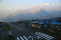
Lukla is often called “world’s most dangerous airport”, but in reality the statistics are not so bad. There is airplane crash only every two years or so :-) But the truth is that to land in Lukla, at altitude 2860m, the plane first needs to maneuver through Himalayan valley, make the landing before daily deadly fog settles around the airport and beat the mountain winds (it’s because of the fog and the wind, that the planes usually land in Lukla only between 6:30am 11:00am) after all of this the plane must land at the airport whose ultra-short runway is sloped 12 degrees (in order to make it possible for the plane to brake before the end of the short runway) and which is ended by a solid rock which says “WELCOME”. I would lie if I said that I wasn’t scared of the flight, but it turned out to be the most beautiful flight of my life – flying through the valley with hills and trees behind your window was like flying on army fighter plane, sort of Top Gun experience. Plus, the view over snowcapped Himalayan peaks – AWESOME! But landing at the airport was really sick – when you see that ridiculously short runway, finished with the rock and the steep hill and the violently blinking red control light in pilot’s cabin keeps on desperately and pointlessly screaming “ALERT! TERRAIN AHEAD” – you feel like praying to all deities of all religions for safe landing. This time, gods were merciful.
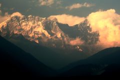
Shortly after landing I started the hike and spent the first night at a small guesthouse being there the only guest, had a good portion of yak cheese (I mean nak cheese - yak is male, nak is female; you don’t want to taste YAK cheese…), which I had first tasted in Langtang, where they had had cheese factory and of which I just can’t get enough. It was relatively short hike, only 3 hours through blooming rhododendrons, and suspension bridges, nothing dramatic, the most “exciting” event being the fact, that condor or some other bird of prey shitted on me, and if you didn’t know condor shit is HUGE, so the next day I had to wash all my clothes that I wore. Next day I hiked the steep climb up to legendary Namche Bazaar at 3400m. Namche is officially the largest Sherpa village (Sherpas are ethnic group from this region, the meaning of the word sherpa as we know it comes from the fact that Sherpas mostly work as porters and guides, i.e. term sherpa was coined like this, anyway most Sherpas are sherpas) but in reality it is a large, super commercial hub of accommodation. Namche is “mandatory” acclimatization stop on the way to EBC, and to prevent getting Accute Mountains Sickness everyone should spend at least 2 nights there, but I relied on the previous acclimatization from Langtang trek, and as I didn’t like Namche very much, I left next morning and made it to next stop Tengboche, but not before spotting the mighty Mt. Everest for the first time in my life. Only the tip of Mt. Everest was visible, first from a viewpoint above Namche and later from Tengboche, but anyway, 11-Apr-2013 will be always remembered (by me) for being the day, when I first time spotted Mt. Everest. The view over Himalayan peaks in the light of setting sun from Tengboche was amazing (this was one of very few days, actually the only day, when the clouds cleared for the evening, as usually after 13:00 all you can see it fog).
When I was kid (not that I would be really grown up now…) we had (I guess my parents still have it) a big plastic map of the world. It was in two pieces – western and eastern hemisphere – and it was a relief map. We never put it on the wall, it was always stuck behind a couch in our living room, but from time to time I used to take it out and look at it. I remember how I always adored the dark brown uplifted part – the Himalayas – and I used to run my index finger through it to touch the relief of this mystical mountains. I remember EXACTLY the point which read “Mt. Everest / Chomolungma , 8848m. I always looked at it with awe, but I never really expected to get here, especially not during my childhood in communist Czechoslovakia, as we could only travel to Soviet Union, Poland, Hungary, Bulgaria and the lucky ones to Croatia – simply to the Eastern Block. And here I was, walking right through this unachievable spot on the map, the darkest brown relief spot on that sacred map of my childhood. It felt strange, almost unreal. I cannot appreciate the fact that I am here strongly enough…
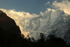
Tengboche was another recommended acclimatization stop, but I skipped it again, as I felt OK and in Langtang I hiked in higher altitudes and so on my third day I arrived to Pheriche, 4200m, our scheduled meeting point with Viktor and Hanka. We didn’t even have to meet at Himalayan Lodge on the pre-agreed time, I literally bumped into them 5 minutes after my arrival, which was 30 minutes after their arrival. Shortly before Pheriche I already felt the first slight dizziness caused by the altitude and as Pheriche was second “mandatory” acclimatization stop on the trek the next day we took a rest and just wandered around the village. Well, village. Past Tengboche there are no villages on this trek, it’s all just collections of lodges for tourist. Pheriche is situated in gigantic glacier valley, which continues all the way to Everest Base Camp to the base of Kumbhu Glacier and icy winds blew down the valley. While Tengboche was still relatively OK temperature-wise, from Pheriche the days of cold began. It was fucking freezing at night and in the early morning when I went to take some photos I thought that my fingers would just fall away right from my hands. Luckily the sun warms you up. Too bad it always disappears by noon and so paradoxically, the warmest part of days are always mornings. As for the views, I will let the photos speak.
From Pheriche on, we trekked together – Viktor, Hanka and me. Walking above 4500m gets difficult and so getting to Lobuche at 4800m was bit of a fight. We slept it a place with I nicknamed MASH 4077. It was a beautifully desolate place, miraculously defying all laws of statics, gravity and civil engineering. But since the room was as tiny as room for 3 persons can get, it was the warmest night of the trek, and our body heat managed to heat the room to a reasonable level (I mean above 5’C) – I even took down my winter cap for some time!!! WOW.
By the way: lodges. Lodges on EBC trek are pretty good: solid beds, good food (but of course that all the guesthouses have EXACTLY the same menu, and you anyway end up eating Dal Bhat, fried rice, fried noodles or apple pie…), often western toilets (!), BUT of course that ll of them are without any heating and thermal isolation and with large single layer glass windows, so horribly cold during the days, not even mentioning the nights. It’s so fucking cold, that you cannot do anything else than smuggle into your sleeping bag and hibernate. Once we finished the hike, hid in our sleeping bags at around 16:00, and only got out next morning at 7:30. COLD, COLD, COLD! I HATE COLD!!! And the tricky part about the lodges is running water. There is no running water practically anywhere. You can either use water from hoses running from mountain streams, or sometimes they put up “home-made sinks”, which is a plastic bucket with a tap at the bottom, but the water is often frozen in the morning, so there is no way to wash your hands (but anyway I gave up this western hedonistic habit long time ago…) or brush your teeth. When flushing down the toilet with a small bucket, you also often have to crash icy crust on the top of the water tank to get some water.
From Lobuche we stumbled to Gorak Shep, 5160m, the last settlement on EBC trek, where we stayed 3 nights, making side trips to Everest Base Camp (5360m) on 16-Apr and Kala Patthar, 5545m on 17-Apr. Kala Patthar, rather a bunch of stocked up stones than a proper mountain, is the highest point I have ever been to (apart from when I smoked hashish in Langtang…), and quite possibly it will remain so until end of my life. Trekking above 5000m gets really nasty, it’s like hiking in the middle of full blown pneumonia.
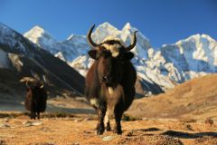
Ever since Tengboche the landscape turned I into desolate tundra and showroom of rocks, glacier moraines, rubble and ice. It was bit depressing, but the surrounding mountains were awesome, the most beautiful ones being Amadablam, Thamserku and Pumori. Everest is pretty dull, but who cares, it IS the highest mountain on this planet, and seeing from 1-2km from Kala Patthar (from all other places its hidden behind other steep mountains) definitely was one of the highlight of my life. I never expected to see Mt. Everest. Now that I saw Kangchendzonga (#3) and Everest (#1) only K2 (#2) remains, but I doubt that I will ever get to see it, being located deep down in Pakistan…
After freezing our asses off in Gorak Shep, we decided to cancel our planned crossing of Cho La Pass to Gokyo Valley, especially after we met one Slovak guy who told us that this week some trekker got his hand cut off by a falling rock and one Sherpa died there. Viktor really wanted to go, but luckily he subdued to pussies like me and Hanka who were whining for some warmth. I’ve spent almost last 2 months in/near Himalayas, which means that with exception of those few nights in Kathmandu and on Annapurna Sanctuary Trek I’ve been freezing every single night for 2 months. I’ve just had enough!
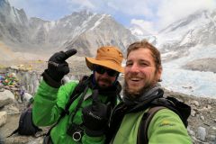
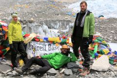
Reaching Everest Base Camp was great feeling and the scenery of Kumbu Glacier was wonderful, although there is no view of Mt. Everest from the base camp. For the views, Kala Patthar was da place, but again the photos speak for themselves.
TO BE CONTINUED...
(This post is split into 2 parts, because it’s horribly long and anyway I cannot upload more than 50 photos per post, so continue with the next post)